|
BEDFORD, NS / ACCESSWIRE / November 4, 2021 / (TSXV:SSE) - Silver Spruce Resources Inc. (the "Company") is pleased to announce a technical services agreement signed with MPX Geophysics Ltd. ("MPX") to conduct an airborne survey of the Mystery Au project ("Mystery" or the "Property"). The Company recently signed a Definitive Agreement to acquire 100% of three early-stage gold exploration properties, Mystery, Till and Marilyn located near Grand Falls, Newfoundland and Labrador, Canada, 20-25 kilometres west of New Found Gold Corp.'s Queensway project and 15-35 kilometres south of Sokoman Minerals Corp.'s Moosehead gold project.
"Given the history of recent exploration discoveries and successful drilling along several major structures in the Exploits Subzone, we are excited to launch our first gold exploration program in the region at the Mystery project. The MPX airborne survey is scheduled for early November and will require only 3-5 flight days, weather permitting, to complete data collection over the entire Property," said Greg Davison, Vice-President Exploration and Director of Silver Spruce.
Image: https://www.accesswire.com/users/newswire/images/671159/SSE1.png
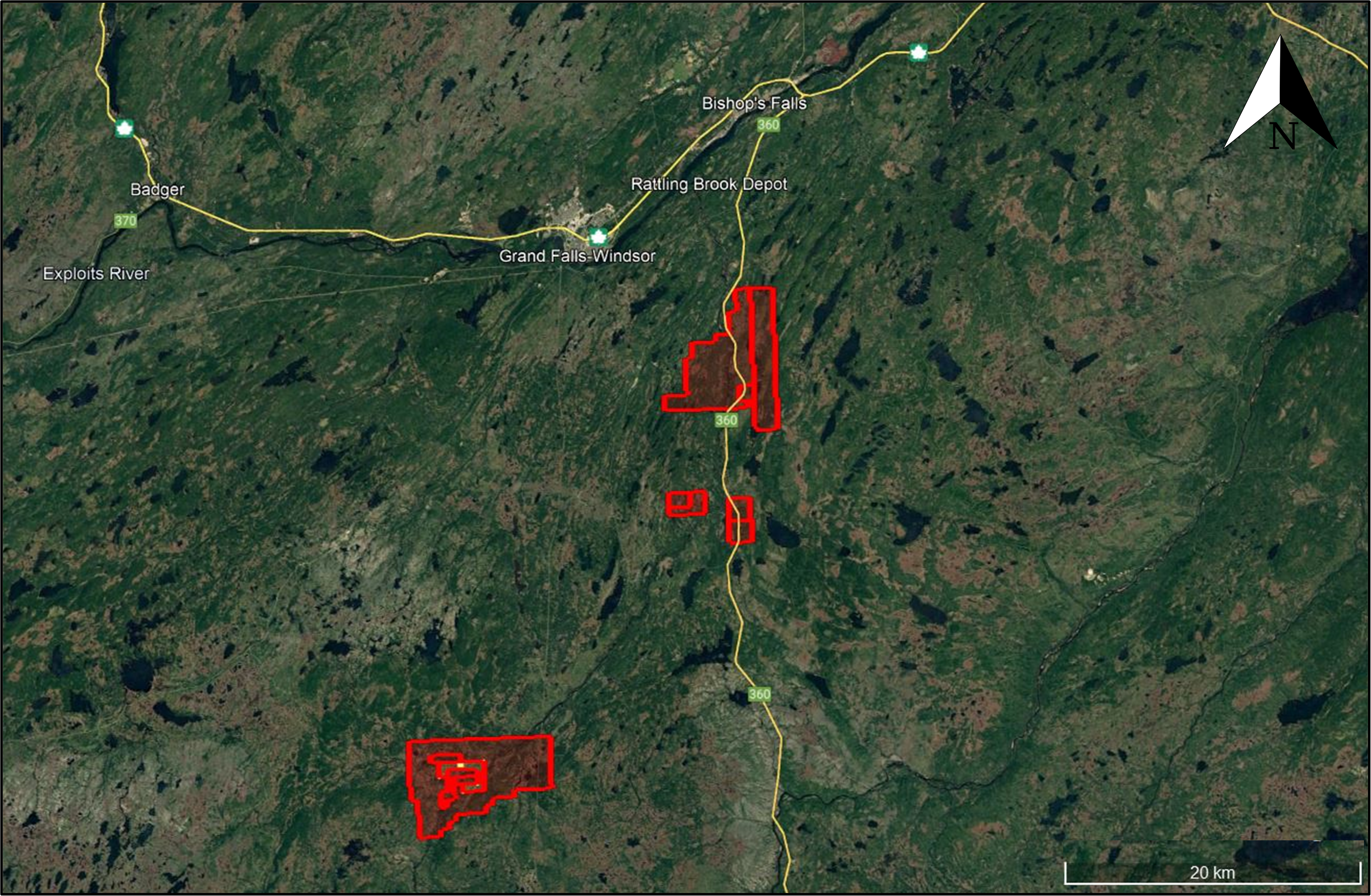
Figure 1. Map of the Mystery project claims, named from north to south, Marilyn, Till and Mystery, located only 20-50km south of the MPX flight base in Bishop's Falls, Newfoundland.
"Our initial site exploration reported mineral and rock textures common to shallow epithermal and/or orogenic 'mesothermal or lode' vein-style mineralization with Au-As±Sb geochemical association. These points are consistent with the regional discoveries and significant global analogues. We are targeting major and minor structural sets, zones showing strike shift and potential dilation, zones of high resistivity associated with one of more styles of silicification, among other indicators," said Greg Davison, Silver Spruce VP Exploration and Director. "Fortunately, we have prospective regional geology and structure with only limited exploration and no history of drilling. The MPX survey will complement our grassroots project ArcGIS database with state of the art, high resolution magnetic, radiometric and VLF data. MPX has completed similar airborne surveys over several adjacent properties where significant lineaments can be interpreted along anastomosing and intersecting trend s."
MPX Geophysical Survey
The airborne survey will comprise three grids totaling 1,460 line-km along E-W (Marilyn and Till) and N-S (Mystery) flight lines with 100 metre nominal line spacing, and 180 line-km of orthogonal tie lines with 1,000 metre nominal line spacing (Figures 2, 3 and 4). The Piper Aztek aircraft will fly daily from the airstrip at Bishop's Falls located from 20km to 50km north of the Properties.
Image: https://www.accesswire.com/users/newswire/images/671159/SSE2.jpg
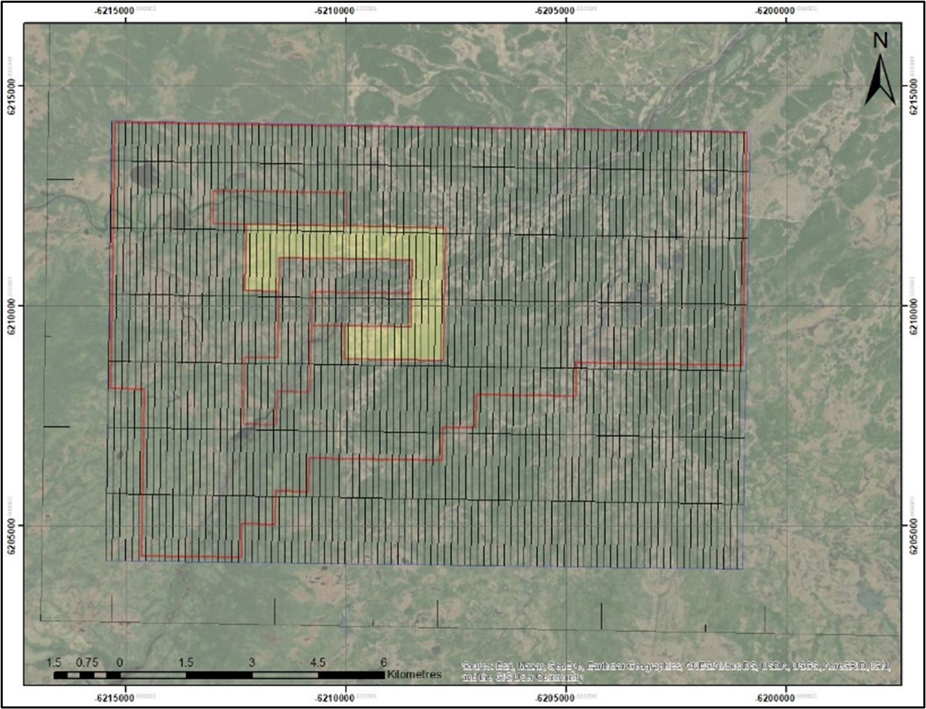
Figure 2. Mystery Claims showing location of MPX Geophysics airborne survey (UTM WGS 84) using 100m flight lines and 1000m tie lines. Base map - World Imagery.
The aircraft airspeed will be 130-150 knots. Optimum terrain clearances for the aircraft and instrumentation (magnetometer, spectrometer, VLF) during normal survey flying are 60-70 metres. Vertical position along flight lines will be established using a pressure altimeter, a radar altimeter and GPS height. Final horizontal survey positions will be computed from differentially corrected GPS to a precision of ± 1m.
Image: https://www.accesswire.com/users/newswire/images/671159/SSE3.jpg
Figure 3. Till Claims showing location of MPX Geophysics airborne survey (UTM WGS 84) using 100m flight lines and 1000m tie lines. Base map - World Imagery.
The attitude and motion of the aircraft in flight, with respect to the Earth's magnetic field vector, will be monitored/recorded by a three-component fluxgate magnetometer (Billingsley TFM 100G2 Triaxial Fluxgate Magnetometer), which is very sensitive to attitude changes.
The magnetic sensors utilized for the survey are Geometrics 822A or Scintrex CS3 high resolution cesium split-beam total-field magnetometer which will be installed in a tail stinger. Magnetic compensation of the acquired "raw" magnetometer data will be collected in real-time using the RMS Instruments DAARC500/ARC510 Data Acquisition and Aeromagnetic Real-Time Compensator ("RMS"), together with comprehensive and flexible data acquisition and recording. The RMS offers the ultimate in aeromagnetic compensation.
Radiation Solutions RS-500 multi-channel gamma-ray spectrometer with 33.6 liters "downward looking" NaI sensor, and 8.4 litres "upward looking" NaI sensor will be installed on the aircraft for the survey. The RS-500 supersedes all other airborne systems given its advanced DSP / FPGA technologies. The RS-500 is a fully integrated system that includes an individual Advanced Digital Spectrometer (ADS) for each crystal within the detector box.
Image: https://www.accesswire.com/users/newswire/images/671159/SSE4.jpg
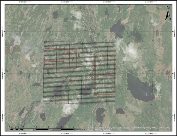
Figure 4. Marilyn Claims showing location of MPX Geophysics airborne survey (UTM WGS 84) using 100m flight lines and 1000m tie lines. Base map - World Imagery.
The Totem VLF sensor utilized for the survey will be a RMSVLF system. This device contains three orthogonal coils, a signal amplifier and it has eight different frequency bands for different VLF transmitters. The VLF system is sampled in the 15-25 kHz. The VLF system employed is configured to simultaneously measure five transmitting stations.
MPX crews will conduct all field activities in Newfoundland and Labrador (NL) under strictly adhered to corporate and client COVID safety protocols.
Exploration Plan
The Company has staged plans to complete, with receipt of NL Mineral Lands Division project approvals, regional till sampling for gold grain analysis and soil geochemistry, prospecting, airborne geophysics, QA/QC program development, ArcGIS geological and geophysical data compilation and as warranted by the Phase 1 results, to undertake a detailed geological mapping and sampling program, grid soil sampling and planning for our first exploration drill campaign.
All aspects of the exploration program will be conducted with strict adherence to COVID-19 protocols for personal safety.
Project Background
The 8,750-hectare project is located within the Exploits Subzone, an extensive area of mineral exploration activity and discoveries over the past two years. The Properties are well situated in terms of exploration logistics, located close to each other and 10-45 kilometres south by Bay d'Espoir Highway from Bishop's Falls, Newfoundland. The Properties are located <70 kilometres from the Gander International Airport and are easily accessible from major paved roads and local logging and bush roads and trails.
The region is structurally complex and located, in large part, between several major crustal lineaments. Numerous major to lesser sub-parallel features merge and bifurcate along strike and are transected by NW and EW-trending faults. These deep-seated structures, which juxtapose geological terranes over hundreds of kilometres, are key to the location and formation of orogenic gold deposits containing several million ounces of gold as reported by junior companies in the district.
The Properties have seen little structured exploration to date. Prospecting by the Vendor is the only exploration conducted during the past ten years. Silver Spruce expedited its initial site visit on the Properties during the week of August 23rd and received an independent positive initial report on the mineral and rock textures potentially related to shallow epithermal and/or orogenic vein-style mineralization. Silver Spruce recently verified sample locations for the historical assays and collected new rock samples. The results remain pending and will be reported in due course.
Image: https://www.accesswire.com/users/newswire/images/671159/SSE5.png
Figure 5. Calcite with quartz replacement, typically associated with epithermal deposits, e.g., hot spring, collected along Great Rattling Brook, Mystery claims.
A selection of historical assays was reported for precious and base metals and pathfinder elements from 123 samples collected from Mystery and Marilyn (see Press Release of September 14, 2021). Eighteen samples reported Au >0.5 g/t (max. 12.5 g/t Au). Cu values were reported up to 9.85% with minor Ag, Pb and Zn. Arsenic was highly anomalous with values for thirty-six samples over the 2200 ppm upper limit for Inductively Coupled Plasma (ICP-OES) analysis, strongly associated with elevated Au values and displayed as minor to abundant arsenopyrite.
Multiple surface occurrences are reported of agate chalcedony to colloform and crystalline silica veining and multi-phase breccias, carbonate replacement by quartz, and open-space filling quartz and calcite, all textures indicative of the upper zones of epithermal systems and structural conduits in orogenic systems and are accompanied by Au and arsenopyrite, stibnite, chalcopyrite, bornite and Cu carbonate mineralization in several host lithologies including quartz veins, black shale and other sedimentary units, and ultramafic and gabbroic intrusions.
All metal values disclosed herein for the Mystery and Marilyn properties by past operators, including the Vendors, and by Silver Spruce are reported from grab samples which may not be representative of the metal grades, or the metal grade distribution, and those from previous exploration efforts must be considered as historical in nature.
Qualified Person
Greg Davison, PGeo, Silver Spruce VP Exploration and Director, is the Company's internal Qualified Person for the Mystery, Marilyn and Till Projects and is responsible for approval of the technical content of this press release within the meaning of National Instrument 43-101 Standards of Disclosure for Mineral Projects ("NI 43-101"), under TSX guidelines.
About MPX Geophysics Ltd.
MPX Geophysics is an international leader in airborne and remote sensing for the mining, O&G, civil and environmental engineering sectors. MPX operational and HSE procedures are industry-leading. MPX has undertaken more than 500,000 line-km of airborne geophysical surveys worldwide operating from both helicopter and fixed-wing platforms, including numerous projects in northern Canada, in remote and difficult locations. Survey technologies include magnetics, radiometrics, electromagnetics, gravity, MT, LiDAR, data processing and interpretation. The MPX Group of Companies is headquartered in Toronto, Ontario, Canada.
About Silver Spruce Resources Inc.
Silver Spruce Resources Inc. is a Canadian junior exploration company which has signed Definitive Agreements to acquire 100% of the Melchett Lake Zn-Au-Ag project in northern Ontario, and with Colibri Resource Corp. in Sonora, Mexico, to acquire 50% interest in Yaque Minerales S.A de C.V. holding the El Mezquite Au project, a drill-ready precious metal project, and up to 50% interest in each of Colibri's early stage Jackie Au and Diamante Au-Ag projects, with the three properties located from 5 kilometres to 15 kilometres northwest from Minera Alamos's Nicho deposit, respectively. The Company is acquiring 100% interest in the drill-ready and fully permitted Pino de Plata Ag project, located 15 kilometres west of Coeur Mining's Palmarejo Mine, in western Chihuahua, Mexico. Silver Spruce recently signed a Definitive Agreement to acquire 100% interest in three exploration properties in the Exploits Subzone Gold Belt, located 15-40 kilometres from recent discoveries by Sokoman Min erals Corp. and New Found Gold Corp., central Newfoundland and Labrador. Silver Spruce Resources Inc. continues to investigate opportunities that Management has identified or that are presented to the Company for consideration.
Contact:
Silver Spruce Resources Inc.
Greg Davison, PGeo, Vice-President Exploration and Director
(250) 521-0444
[email protected]
Michael Kinley, CEO and Director
(902) 402-0388
[email protected]
[email protected]
www.silverspruceresources.com
Neither TSX Venture Exchange nor its Regulation Services Provider (as that term is defined in the policies of the TSX Venture Exchange) accepts responsibility for the adequacy or accuracy of this release.
Notice Regarding Forward-Looking Statements
This news release contains "forward-looking statements," Statements in this press release which are not purely historical are forward-looking statements and include any statements regarding beliefs, plans, expectations or intentions regarding the future, including but not limited to, statements regarding the private placement.
Actual results could differ from those projected in any forward-looking statements due to numerous factors. Such factors include, among others, the inherent uncertainties associated with mineral exploration and difficulties associated with obtaining financing on acceptable terms. We are not in control of metals prices and these could vary to make development uneconomic. These forward-looking statements are made as of the date of this news release, and we assume no obligation to update the forward-looking statements, or to update the reasons why actual results could differ from those projected in the forward-looking statements. Although we believe that the beliefs, plans, expectations and intentions contained in this press release are reasonable, there can be no assurance that such beliefs, plans, expectations or intentions will prove to be accurate.
SOURCE: Silver Spruce Resources Inc.
|


